Eastern Pacific records its most energetic hurricane season
Scientists suspect this may be a symptom of climate change — and more scary storms to come
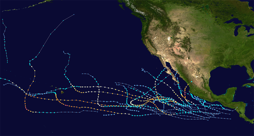
This map tracks all of the major 2018 tropical storms that trekked across the Eastern Pacific toward North America’s West Coast. Their strength is marked by their color, from darker blue (lowest speed) to yellow and red (increasingly strong hurricanes).
FrancoLeymas/Wikimedia (CC BY-SA 4.0)
The Atlantic hurricane season certainly hit the United States hard this year. First came Florence. That storm dropped 91.3 centimeters (35.9 inches) of rain. Then Michael roared ashore as the third most-intense U.S. tropical cyclone to ever hit landfall. But the eastern Pacific had it even worse. As of October 22nd, this region recorded its most energetic cyclone season on record.
That big — and scary — assessment comes from Phil Klotzbach. He used to work for the National Hurricane Center in Miami, Fla. Now he works at Colorado State University in Fort Collins. There, he analyzes tropical storms and hurricanes. He calculates how much energy they release. That energy is expressed as a numerical score known as ACE. It’s an abbreviation for Accumulated Cyclone Energy. These scores have been kept since around 1970.
Klotzbach and other atmospheric scientists use ACE measurements to describe the amount of destructive force unleashed by a storm’s winds over its life. To figure it out, scientists take the maximum sustained wind speed within the eyewall of a storm. It’s measured in knots. Then they square that number. To account for variations in the storm’s strength, this process is repeated every six hours. Once a storm has fallen apart, researchers tally up the energy estimates computed from each six-hour chunk of a storm’s lifetime.
The results are pretty big numbers! To make the digits more manageable, scientists normally divide the total by ten. To see how a hurricane season stacks up, they keep a running sum and compare that year’s score to those for other years. The hurricane season is longer in the Pacific Ocean than in the Atlantic. It runs from May 15 to November 30. (In the Atlantic, it runs from June 1 to November 30.) That’s because the waters in the eastern Pacific tend to be much warmer, thanks to the structure of its ocean currents.
By late October most years, the ACE score for storms in the eastern Pacific totals around 125.7 units. So far this year, storms have churned out a staggering 305 units! That’s how scientists know it’s been a really bad year.
These numbers, by the way, come from tallies for storms in the ocean basin that’s east of the International Date Line. (This imaginary north-south line passes through the middle of the Pacific Ocean.) West of there, tropical cyclones are called typhoons. Near the Date Line, there’s a natural lull in storm activity.
There may be more to come
Keep in mind, there is still another month left in the eastern Pacific hurricane season. Despite this, 2018 has already claimed the top spot since recordkeeping began. It’s above the season-long 295 ACE units counted in 1992, and the 297 tally for 2015. In the coming weeks, this year’s ACE total could top 350 or 400! Simply stated, we’re in uncharted territory.
So what churned up so much Accumulated Cyclone Energy? At least 10 major hurricanes developed in that region this year. Each reached Category 3 status or greater. That means they had winds of 179 to 209 kilometers (111 to 130 miles ) per hour. Of these, four climbed to Category 4 status. Another 3 reached the top tier — Category 5. Those potentially lethal storms boast winds stronger than 251 kilometers (156 miles) per hour. For perspective, this year is only the third in recorded history to generate three Category 5 storms in the eastern Pacific.
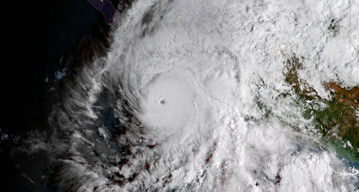
Such monster storms can wreak havoc wherever they strike. On October 22, Hurricane Willa was the year’s third Category 5 storm. Its winds revved up to 257 kilometers (160 miles) per hour. En route to Mexico, it then weakened to a Category 3 hurricane. Even after making landfall shortly after midnight on October 24, it held its Category 3 intensity.
The two other Category 5 hurricanes — Lane and Walaka — used up most of their destructive energy whirling offshore. Walaka even danced the “Typhoon Tango.” It spun in the eastern Pacific while a typhoon of Category 5 strength spun thousands of kilometers to the west.
Lane, meanwhile, took an unusual track that brought it to Hawaii. It dropped 132.13 centimeters (52.02 inches) of rain in an unprecedented September deluge. This came months after an ordinary springtime rainstorm in April doused Waipa, on the island of Kauai. That storm dropped a mind-boggling 126.21 centimeters (49.69 inches) in less than 24 hours.
But Lane wasn’t a solo event. Two weeks earlier, in late August, Hurricane Hector also clipped the Hawaiian islands with gusty winds, rough surf, high waves and blinding squalls. They say that two’s a party, but three’s a crowd. And sure enough, a third tropical cyclone — Olivia — swung by Hawaii just after Lane’s rampage.
This marks the first year on record when a trio of windstorms has directly affected Hawaii. Normally, the islands’ position is far enough to the northwest of the region’s main danger zone to be largely immune to such cyclone smacks.
Climate lessons from Hawaii?
Hawaii may find itself pummeled by hurricanes even more in coming years. The reason is climate change, according to scientists at the University of Hawaii at Mānoa. They work at its Department of Meteorology and the International Pacific Research Center in Honolulu.
Bin Wang works at the Honolulu center. He warns that his team’s models indicate “a substantial increase in the likelihood of tropical cyclone frequency … with a northwestward shifting of the tropical cyclone track.” That would put the southern Hawaiian islands directly in a path that future storms are more likely to take.
Hawaii’s not the only place this season to be impacted by “out of bounds” Pacific storms. Both Rosa and Sergio entered the United States’ desert southwest as remnant tropical rainstorms earlier this year. The former brought 8 to 12 centimeters (3.1 to 4.7 inches) of rain to Arizona. The resulting flash floods triggered mudslides and debris flows.
Such drenching in the Grand Canyon State may be a symptom of a rapidly changing climate. The Intergovernmental Panel on Climate Change advises that flooding is more likely across the southwestern United States as tropical moisture is able to stream farther northwards. And that’s thanks to our warming globe.
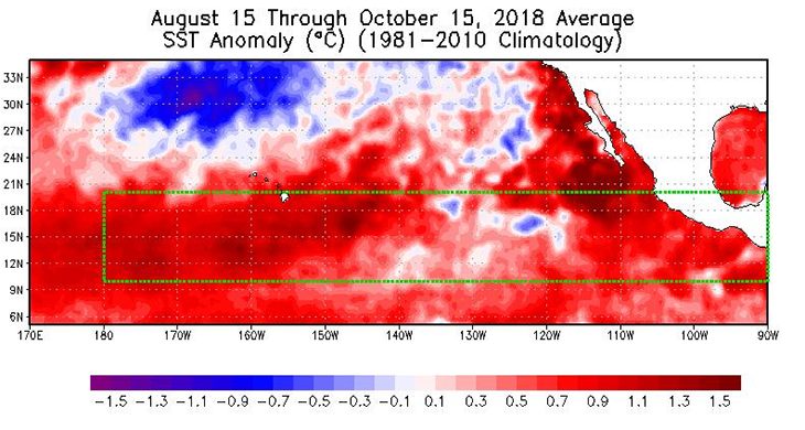
So what made 2018 so wild? Klotzbach points to two things. One is low amounts of wind shear in the upper atmosphere. The other is far higher-than-normal sea-surface temperatures.
“The northeast Pacific was quite toasty this year,” he says. “Sea-surface-temperature anomalies were 1 to 1.5 degrees Celsius [1.8 to 2.7 degrees Fahrenheit] warmer on average across the basin.” That’s a primary factor, he explains, behind the growth of cyclones.
But there was something else.
Weaker-than-normal winds in the upper atmosphere led to a drop in wind shear. That’s a turning of the winds with height. If the winds veer too much, they can tear apart an infant storm before it can grow into a towering monster. But Klotzbach points out that wasn’t an issue this season. “We had reduced shear throughout the [eastern Pacific] basin for most of this year.”
This year’s spike in hurricane activity, he notes, is surprising in the absence of an El Niño. That term describes a period when winds reverse directions near the equator in the Pacific. During El Niño years, the normally easterly trade winds become westerly. This leads warm waters to pool off of the west coast of Central America. That’s a prime site for the formation of Pacific hurricanes. Even without that El Niño, hurricanes erupted anyway. Blame the region’s super-warm seas.
“It doesn’t always take an El Niño event to increase northeast Pacific hurricane activity,” explains Klotzbach. There was no El Niño this year. Nor was there one in 1992, he notes. But both years still emerged as “the most active seasons as measured by ACE.” There may be no overall increase in the number of future hurricanes. But climate scientists expect storms that do arise to become increasingly strong and more destructive as global warming continues to raise the temperature of sea-surface waters.
And that’s not the only fingerprint of climate change showing up in big storms. More and more hurricanes erupt into monsters within a day or less. That fast change is called rapid intensification. The pattern marks cyclones whose winds pick up by at least 55.5 kilometers (34.5 miles) per hour within 24 hours. Hurricane Florence did this in 2018. So did Michael; it revved up from a weak tropical storm to a Category 4 cyclone in less than two days. And it continued to gain strength right up to its landfall in the Big Bend of Florida on October 10. By then, it had winds as strong as a tornado’s.
In the Pacific, more than four in every five tropical cyclones this year underwent such a rapid strengthening. That’s according to Brian McNoldy. He’s a hurricane researcher at the University of Miami in Florida. Back in late August, he notes, Hurricane Norman vigorously strengthened by 129 kilometers (80 miles) per hour in fewer than 24 hours.
Meteorologists warn that this rapid intensification of cyclones will become more common in the years ahead. It is but one symptom of a warming planet.