Heat signatures help track down old and still deadly land mines
A drone-mounted infrared camera could aid in locating the old explosives so they can be removed
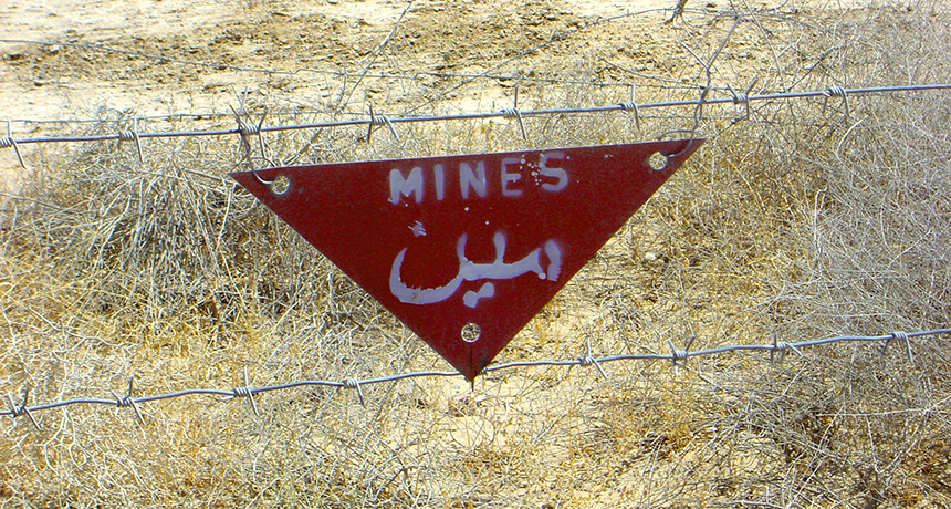
This sign in English and Arabic warns pedestrians that live land mines still litter this field in Afghanistan.
manxman/iStock/Getty Images Plus
WASHINGTON, D.C. — Even when a war is over, the killing can continue. Land mines left behind in former conflict zones can still claim casualties. Now, researchers have developed a technique that can help spot one type of plastic-based mine. It’s a type that is very hard to spot. One day, this new technique might be used to locate and eliminate those explosives — especially in fields where children now play.
In late 1979, troops from the Soviet Union invaded Afghanistan, a nation in south-central Asia. In the more than nine years the Soviet troops were there, they spread a lot of land mines, says Alex Nikulin. He’s a geophysicist at Binghamton University in New York. These weren’t big explosives, the types designed to target tanks. Instead, the soldiers’ intent was to hurt or kill people. Made largely of plastic, these mines can be quite difficult to find the usual way — walking around with metal detectors.
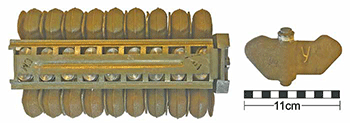
Soviet helicopters dropped millions of these mines, each small enough to fit into the palm of an adult’s hand. Their official name is the PFM-1 mine. But owing to their shape, people often call them “butterfly mines,” notes Jasper Baur. He’s a geology student at Binghamton University. Baur was part of a team — one that included Nikulin — that developed the new mine-spotting technique.
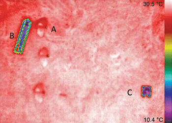
The Soviets often painted the butterfly mines with colors that helped them blend into the background. That helps the human eye miss them, explains Baur. His team’s innovation relies on thermal inertia, a trait that many materials have. Inertia is the tendency of an object to remain in place, even if something is pushing on it. Thermal inertia is the tendency of an object to remain at a constant temperature even as its environment is warming or cooling down. So when air temperatures are changing fairly rapidly, an object lying on the ground may tend to retain its temperature longer than the rocks and soil around it. And a special camera that senses heat — or infrared wavelengths — should be able to highlight objects that are cooler or warmer than the ground around them.
To test the idea, the team mounted an infrared camera on a drone. Then they flew the robotic craft back and forth over an area. They had already placed a few faux mines at the site — ones with no explosives. They also added a few of the small metal racks used to hold such mines before they are dropped from a copter. Finally, the researchers used computer software to create video images from the drone’s camera data.
When the team analyzed the infrared images, it was often easy to eyeball the mines. They had been cooler than the surrounding rocks, making them show up as a different color on the image. That color difference was often stark in images taken some 30 minutes to 2 hours after sunrise. That’s when the land was warming quickly. The technique also worked well when data had been collected soon after sunset, as the land was cooling. These are times when the temperature difference between the mines and the rocks was typically greatest.
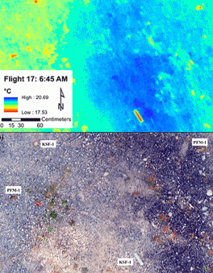
In tests, the researchers could detect about eight out of every 10 faux mines. And they picked out the metallic racks in those images each and every time. Baur’s group shared its new findings here, last December, at the annual meeting of the American Geophysical Union.
Speeding the search for mines
Based on these data, the team estimates that its drone-based camera system can scan an area about 20 meters (66 feet) long and 10 meters (33 feet) wide in 10 minutes or less. That would greatly speed up the search for mines, Baur and Nikulin say. To carefully look for mines on foot in an area that size (about one-third the size of the infield in a baseball field) could easily take hours, they note.
Sayed Agha Atiq is a technical advisor to the United Nations’ de-mining operations in northeastern Afghanistan. There, he works out of the city of Kunduz. The Binghamton team’s technique is “interesting and somewhat promising,” Atiq says. Still, he cautions that it might be challenging to use in the mountainous areas where he works.
Mohammad Wakil Jamshidi agrees and explains why. Based in Kabul, Afghanistan’s capital, he and his boss supervise United Nations de-mining efforts throughout Afghanistan. They also provide technical support for the country’s program to locate and remove mines. And here’s one potential problem, Jamshidi says: Sunlight may reach the valley floor for only a short time each day. Plus, trees and bushes may shade the ground. Such conditions would limit the amount of sunlight reaching the surface to heat it up. So many northeastern Afghan sites may not experience the rapid ground heating and cooling on which this technique relies. Jamshidi would expect, therefore, to see less thermal inertia of mines there than in regions where the terrain is flat. Vegetation would also make it difficult for a drone-mounted camera to see the ground.
Also, for much of the year snow covers the ground. That blanket, Jamshidi points out, will block the view of any mines it covers. Finally, mines on steep slopes can become buried over time. In that case, soil would block the view.
All of these factors might prevent detection of mines by the new technique, he suspects.
Fazel Rahman works in Kabul for Afghanistan’s de-mining agency, the National Mine Action Authority. He says that a field trial of the team’s mine-finding technique would help determine how useful this novel technology might be.
Binghamton University Geophysics
This is one in a series presenting news on technology and innovation, made possible with generous support from the Lemelson Foundation.