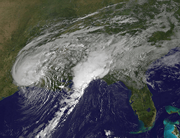
Hurricane Harvey’s rains set U.S. record
Of the threats posed by tropical cyclones, inland flooding is the among the most dangerous
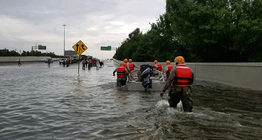
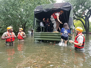
Hurricane Harvey flooded highways and roads in the Houston area. Rescuers sometimes had to travel by boat instead of car or truck.
Lt. Zachary West/Texas National Guard/Flickr (CC-BY 2.0)
Hurricanes are extreme storms. And when they rain, they can pour — hour after hour after hour. Just ask anyone in the vicinity of Harris County, Texas. It includes Houston, the fourth largest U.S. city. And since a storm named Harvey made landfall as a category 4 hurricane late August 25, torrents of rain have deluged the east-central Gulf coast of Texas.
The slow moving tropical cyclone stalled over the state — for days. So the water kept coming. And coming. And coming.
More than 1.2 meters (4 feet) of water fell in some parts of East Texas, according to the National Weather Service (NWS) office in Houston. Flooding prompted widespread water rescues across the greater Houston area (some 80 kilometers, or 50 miles, from the coast). This region is home to nearly 6 million people. And by the fourth day of Harvey’s rains, flood waters already covered an estimated one-third of Houston’s more than 1,550 square kilometer (600 square mile) area.
A rain gauge in Houston’s Cedar Bayou logged a staggering 131.78 centimeters (51.88 inches) of rain, the NWS tweeted out of its Houston office. That was as of 3:40 p.m. August 29. This surpassed the old record for a tropical storm in the continental United States. That record is 122 centimeters (48 inches). It was set in 1978, also in Texas, when tropical cyclone Amelia blew through.
The only U.S. storm to drop more water in one place was Hurricane Hiki. This 1950 cyclone unleashed 132 centimeters (52 inches) of water on the Hawaiian island of Kauai. (Those rains triggered dozens of mudslides and more.) When measurements of Harvey’s totals are complete, scientists expect it will have toppled Hiki’s record.
Meanwhile, even six days into the disaster, conditions in Texas had not abated. Since Harvey hit, at least 6 million Texans have seen more than 76 centimeters (30 inches) of rain, the NWS reports. It has summed up this storm as simply an “unprecedented and historic” rainfall “catastrophe.”
Flooding can be disastrous — and deadly
The rain didn’t just fall and then run back into the ocean. Much of it has been collecting throughout East Texas cities. First it filled low-lying streets and ditches. Then it swelled the bayous that wind through some of these towns. More water collected behind big lake-size reservoirs. (Those reservoirs began spilling over for the first time in history.) Eventually, there was nowhere else for the water to go. The result: Massive, catastrophic flooding.
Hurricanes are known for their extreme winds and devastating storm surges. But many people don’t appreciate the destructive force caused by the flooding that can occur inland — sometimes far from where a cyclone made landfall.
That is, however, something that a scientist with the National Hurricane Center in Miami, Fla., tried to drive home three years ago. Edward Rappaport is currently the acting director at the center. In a March 2014 report, he noted that when it comes to tropical cyclones in the United States, “Rainfall-induced freshwater floods and mudslides accounted for about one-quarter of the deaths.” (It’s actually a bit more than that: 27 percent.)
Storm surges can slam coasts with water that reaches 3.7 meters (12 feet) high or more. And, indeed, “Storm surge was responsible for about half of the fatalities,” he noted. What about wind-related impacts — such as roofing material and toys or porch chairs that can be lofted into the air and slung about like missiles? These accounted for a mere 8 in every 100 cyclone-linked deaths.
Rappaport’s analysis appeared in the Bulletin of the American Meteorological Society.
The science behind Harvey’s punch
A mix of factors made Harvey a recipe for disaster. For starters, Houston alone is home to 2.3 million people. It’s also America’s fastest growing urban area. Development there has been transforming thousands of hectares (acres) of exposed ground into concrete roads, buildings and parking lots. And these hard surfaces keep water from draining into the ground.
The water can quickly collect into raging floodwaters.
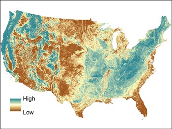
Because the ground is unusually flat in the greater Houston area, rainwater doesn’t rush to run off. This region also sits atop soil known to be relatively impermeable. The U.S. Geological Survey explains this as ground that has a hard time draining. Excess water tends to collect and stagnate atop the ground in Houston, rather than percolating deeply into it.
In addition, Harvey’s winds were accompanied by an exceptionally moist mass of air. One value meteorologists use to estimate the potential for every rainfall is called the PWAT. It stands for Precipitable WATer. It’s a gauge of how much water the clouds are holding.
A PWAT value of 8.3 centimeters (3.25 inches) means that the column of air holds that much water. And Harvey’s air had such a PWAT as it was sitting over Houston. That amount alone may not seem impressive. But consider a wet washcloth. If you wring it out, you won’t fill a bucket. But then you’re handed another washcloth to wring out. And then another. And another. And another. Soon enough, that bucket will be overflowing!
With onshore winds continually replenishing Harvey with more moisture picked up over the warm Gulf of Mexico, this storm had no shortage of humidity to tap into — and release!
Where does Harvey rank against other storms?
Marc Chenard is with the National Oceanic and Atmospheric Administration. He’s at the agency’s Weather Prediction Center in College Park, Md. This meteorologist has been closely monitoring Harvey for more than a week. “While some [rain] totals soared to record levels approaching 50 inches [127 centimeters], what was really remarkable was just how large of a region in southeast Texas saw amounts climbing to above 20 inches [51 centimeters],” he said. “The flooding has been so much worse given the magnitude of the area impacted.”
His center was even forced to add two new colors of purple to the maps it uses when forecasting rainfall. It points to how this event has literally been “off the charts.”
Harvey has underscored the importance of taking all tropical cyclones seriously, even those that may not be classified as a tropical storm or full-blown hurricane. In Rappaport’s study, “six of the 10” most deadly tropical cyclones that he studied were not major hurricanes. Instead, they registered as “tropical storms or category 1 hurricanes at landfall.” (Major hurricanes are those rated category 3 or higher.)
One of the biggest factors that contributed to Harvey being a worst-case nightmare for the Gulf Coast has been its speed, or lack thereof. As of August 29, the storm’s center was still fewer than 322 kilometers (200 miles) from where its rampage began. Its average forward speed was under 3.2 kilometers (2 miles) per hour. This means broad areas found themselves trapped underneath the same enormous bands of rain for agonizingly long periods.
And here’s why storms with extreme winds or rains are likely to be increasingly common in years to come. As climate change takes hold, upper-atmosphere winds slacken. This ups the chance a storm will stall. Warming temperatures also increase the air’s ability to hold moisture. But what goes up must come down, eventually. And as Harvey has shown, that moisture can pour out by the bucket-full. When those storms move at a snail’s pace, they can foster flooding.
Scientists worry that storms rivaling the intensity of Harvey are more likely in the future. It’s alarming to consider that Harvey may have given people a taste of what the future of weather might hold. They say that’s yet another reason why the changing climate should be on everybody’s radar. And as past storms have made clear, hurricanes are not a threat merely to coastal towns. Their danger zone can extend far, far inland.