The odd ways that weather can unfold in a warming world
There may be more rainfall and droughts — as well as colder winters in Siberia
This is the third in a 10-part series about the ongoing global impacts of climate change. These stories will look at the current effects of a changing planet, what the emerging science suggests is behind those changes and what we all can do to adapt to them.
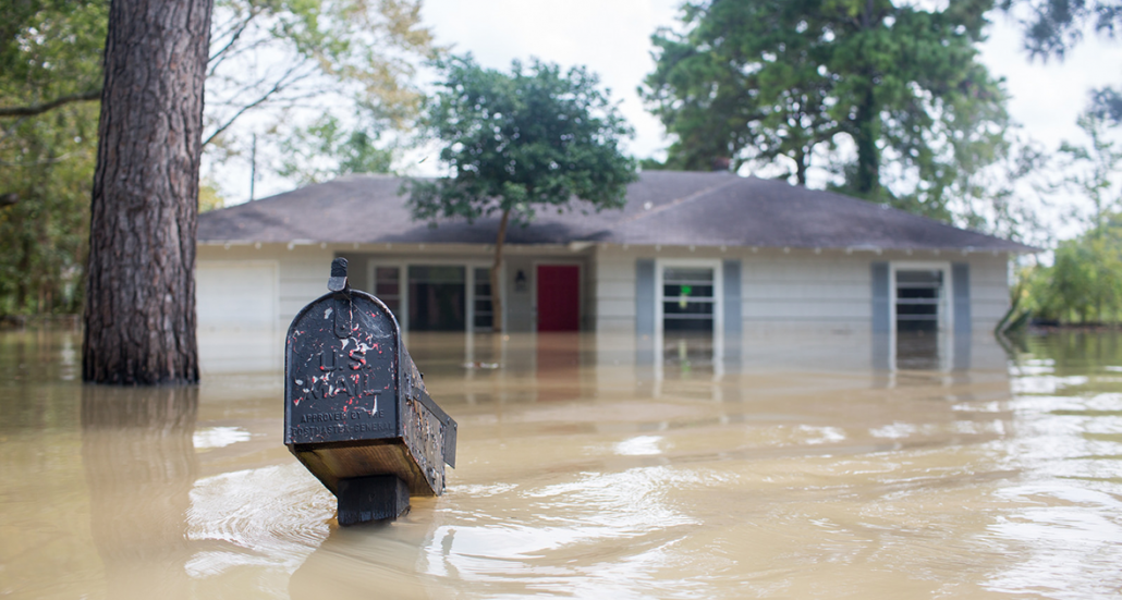
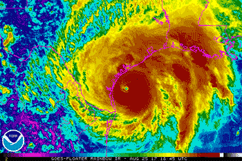
Hurricane Harvey slammed into Houston, Texas, on August 25, 2017. Normally, hurricanes keep moving. Their high winds and torrential rains tend to last for only a brief time. But Harvey just sat over the city. For days. And it dumped a lot of rain. Really, a lot. By the time the storm had moved on, on August 29, it had drowned Houston with a whopping 164 centimeters (64.6 inches) of water, according to one rain gauge. That’s a record rainfall from one storm in one place in the continental United States. In fact, Harvey dumped so much rain that the National Weather Service had to add new colors to their rainfall maps of the event.
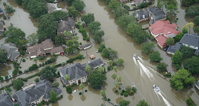
Rising waters inundated more than 300,000 homes. That drove around 40,000 residents to take refuge in shelters across Texas and Louisiana. And of the some 100 people who died during the storm, more than 65 perished from flooding. Including damage from strong winds, researchers estimate that the storm caused more than $125 billion in damage. That tally makes Harvey the second-costliest hurricane to hit the U.S. mainland.
Hurricanes are a normal part of summertime weather. Since 1966, when satellites began daily monitoring of the North Atlantic Ocean, there have been an average of six hurricanes — and never less than two — per year. But more and more studies are revealing that human-caused climate change is influencing the size and fury of these storms.
And heavier rains and stronger storms are not the only ways in which a warming world is making our weather weirder. Higher temperatures can trigger droughts. Heat waves become more likely, and droughts can make them even worse. There can be changes to both global and local weather patterns. And the effects won’t always be what’s expected. In one truly odd twist, the continuing loss of summertime sea ice in the Arctic Ocean — one big result of a warming world — could make Siberian winters colder. What could be wackier than that?
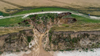
Karl Spencer/iStockPhoto
Whence the weather?
Take a look outside. Is it hot and dry or cool and rainy? Cloudy or clear? Windy or calm? These are all aspects of the weather where you are. Simply put, weather is a snapshot of what’s happening in the atmosphere at a particular time and place. Lots of things affect the weather. That’s why meteorologists may have difficulty predicting what next week’s weather may be in any particular spot. Climate scientists, in contrast, have a pretty good handle on overall patterns of global weather.
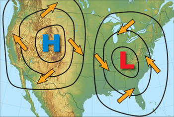
Differences in how some regions heat up compared to others have a big influence on the weather. For instance, near the poles, the sun almost always hugs the horizon. In some seasons, one polar region basks in round-the-clock sunshine while the other languishes in darkness. These sorts of heating differences can trigger the development of high- and low-pressure areas in the atmosphere, says Sean Sublette. He’s a meteorologist with Climate Central in Princeton, N.J. That organization brings together scientists and journalists who research and report facts about Earth’s changing climate and its impacts.
Because air flows away from areas of high pressure, heating differences ultimately create winds. Over broad regions and long distances, winds travel on slightly curving paths due to Earth’s rotation. In the Northern Hemisphere, winds travel clockwise around a high-pressure system. Air rushing into a low-pressure area north of the equator generally swirls in the other direction. (If you pay close attention to weather reports during the nightly news, you can see these motions depicted on weather maps.)
On a more local scale, weather is often affected by the clash of air masses, notes Sublette. Thunderstorms, for example, can erupt where warm, humid air collides with cooler air. This triggers water vapor to condense. Eventually it falls as rain.
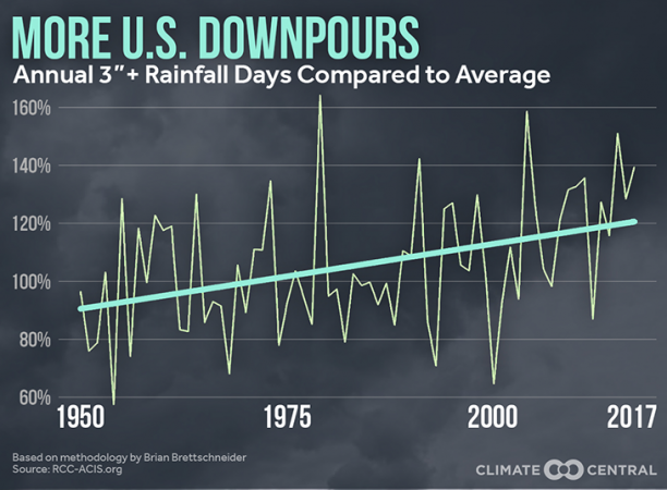
In recent decades, scientists have noted that episodes of heavy rains have become more common. In large part, says Sublette, that trend has been triggered by climate change. Scientists have noted that global average temperature has been, for the most part, rising steadily throughout recent decades. And for every 0.6 degree Celsius (1 degree Fahrenheit) increase in air temperature, the amount of water vapor the air can hold increases about 4 percent.
“Climate change is supercharging the water cycle,” he explains. Warmer air causes more water to evaporate from lakes, seas and moist soil. Now there’s more moisture in the air that can condense into raindrops. This is one source of bigger downpours, he notes.
In the United States, yearly precipitation for the lower 48 states has increased about 4 percent since 1901, a recent report found. In particular, clusters of thunderstorms in the central United States during warm months have been developing more often and dumping more rain. That’s especially true since 1979, the researchers note.
David Easterling helped to put together the report. He’s a climate scientist at the National Centers for Environmental Information in Asheville, N.C. The frequency and intensity of storms are projected to increase nationwide for the rest of this century, he says. But not all areas of the country will suffer the same rates of increase. The U.S. Southwest will likely see smaller increases in rainfall than northern states. But maybe that’s not surprising, because southwestern states typically are drier than others.
Rainfall going to extremes
Across the Houston region, Hurricane Harvey dumped an average of about 84 centimeters (33 inches) of water. That’s probably more rain from one storm than the region had seen at one time in centuries, a new analysis suggests. What’s more, the study hints, that sort of furious rainfall could easily occur much more often in the future.
As our planet has heated up, so have its seas. The warmer those waters are, the more water that will evaporate from the ocean surface, notes Easterling. The energy stored in warm tropical waters fuels the tropical storms known as hurricanes, cyclones or typhoons, depending on location. The more moisture present in a storm’s clouds, the more that can fall as rain.
Kerry Emanuel is an atmospheric scientist at the Massachusetts Institute of Technology in Cambridge. Late last year, he used computer models of hurricanes to estimate how often Harvey-like rainfalls have deluged the Houston area. Then, he used the same computer programs to look into the future. And his results aren’t encouraging for the folks in Texas, where Harvey’s flooding displaced thousands of residents.
Emanuel started by creating thousands of cyber-storms. If one of the storms in these computer simulations passed within 300 kilometers (190 miles) of Houston and had winds higher than 74 kilometers (46 miles) per hour, he made an estimate of how much rain it would have dumped. If conditions were always like those in the late 20th century, he found, Houston likely would see storms dump 50 centimeters (20 inches) or more only once every 2,000 years.
Then, he ran the same simulations again. Now he used climate conditions expected to occur between 2081 and 2100. Greenhouse-gas levels might be a lot higher during those years. And during this period, the Houston area might experience major deluges once a century, not once every two millennia. Emanuel reported his findings November 13, 2017 in the Proceedings of the National Academy of Sciences.
People often think of climate change only as a problem for the future. But Emanuel’s analysis reveals that that’s not true. Over the course of 100 years, he found, the chances of extreme rainfall increased about 18 percent. So, if the risk of extreme rainfall in the Houston area is steadily increasing, then the chances of the region seeing Harvey-like precipitation is today about six times what is was just 20 years ago. And because temperatures are rising worldwide, on average that means the chances globally of extreme flooding are on the rise, too.
Droughts and heat waves
Studies have shown that droughts, like the one that plagued California from 2011 to 2017, also will occur more often in the future. So will heat waves. Again, both are due to climate change. But a new analysis hints at something even more dire: They will happen more frequently. And when these phenomena both occur at the same time, each will reinforce the effects of the other.
Heat waves are extended periods marked by temperatures much higher than average for that particular region. Consider the summer of 2018. In late June and early July, an excessive heat wave in the United Kingdom may have killed hundreds of people. In early July, a five-day heat wave — including one day of record-breaking temperatures — hit Montreal, Canada. Researchers estimate some 70 people there also died, due at least in part due to the heat. A few weeks later, Japan suffered a two-week-long heat wave. This heat spell killed dozens and sent thousands more to the hospital.
In the future, such heat waves will occur more frequently for two reasons. First, climate change has boosted temperatures in most regions. That means higher-than-normal temperatures are themselves more common. But climate change, in general, also has weakened a high-altitude river of strong winds. Known as the jet stream, it helps push weather systems from west to east. A weaker jet stream means that weather systems of all sorts, whether heat waves or flooding rains, move more slowly. So storms have a better chance of dropping more rain in one spot. And heat waves have a better chance of hanging around longer.
In a warming world where rainfall is gradually increasing, it doesn’t seem as if drought should be a problem. But oddly, Sublette observes, both rainfall and drought can both be on the rise. “You’d think everything would balance out, but that’s not the case,” he says. Warmer temperatures will increase evaporation. That pulls more moisture from soil and sends it into the atmosphere. When that moisture falls back to earth as rain, sometimes it can’t soak into the soil quickly enough. So it runs off into rivers and streams. That’s especially true when the rains fall in extreme amounts, he explains.
Droughts and heat waves by themselves are bad enough. But together, they can be especially devastating, says Felicia Chiang. She’s a hydrologist at the University of California, Irvine. (Hydrologists study the flow of water, especially in its liquid form, over and through Earth’s surface.) Chiang’s team recently looked at the combined effects of heat waves and droughts in the continental United States.
When water evaporates, or transforms from a liquid to a gas, it soaks up a lot of energy. Evaporation dries out the soil, of course. But it also cools the air and ground. (Think of this process as the planet sweating.) Now, consider what happens in an area that’s in the middle of a drought. With little or no moisture in the soil, a lot more of the sunlight’s energy goes toward heating the ground, says Chiang. That, in turn, heats the air a lot more than it would have if the soil had been moist.
In their new analysis, Chiang and her teammates looked at weather data collected in the lower 48 states during two 50-year-long windows of time. One lasted from 1902 through 1951. The other one stretched from 1965 through 2014. First, they calculated the temperature difference between these two eras. And the more recent era was, on average, 0.25 degree C (0.45 degree F) warmer than the early 20th century. That was due to climate change, she notes. Then, the team calculated the temperature difference between the two eras only for sites experiencing droughts — and then only during those droughts. The temperature increase during the later era at these sites during their droughts was 1.06 degrees C (1.9 degrees F). Chiang and her teammates reported their findings August 1 in Science Advances.
This trend will only worsen with time. The drought-induced boost in heating will have widespread effects, the researchers suggest. While cities swelter in extended heat, crops in the countryside may be stunted or fail. Wild animals as well as livestock will suffer. And the wildfires that plagued drought-stricken areas from California to Greece this summer may be just a preview of what’s in store.
Unexpected effects
In general, it makes sense that droughts could make a heat wave worse. But who would expect that in a warming world, some areas would actually get colder? That’s exactly what scientists have noticed in recent years about winters in Siberia. The odd weather pattern is so unusual — and has been so baffling for so long — that scientists have given it a name. They call it the “warm Arctic, cold Siberia,” or WACS. Now, researchers may have come up with an explanation for this puzzling trend.
Previous attempts to explain the WACS trend had been unsuccessful, notes Pengfei Zhang. He’s an atmospheric scientist now at the University of California, Santa Barbara. A number of teams had tried to duplicate the trend using computer models. But he says none were successful. Some people pointed to those failures as proof that climate models are no good. Others used the models’ findings to dismiss the idea of climate change being real, says Zhang. Those skeptics suggested that what many scientists call “global warming” was actually just natural variability in climate.
Zhang and his teammates decided to investigate more deeply.
NASA Video/YouTube
Many previous teams had relied on climate models that lacked many details. In particular, he notes, depictions of the atmosphere above the troposphere (TROH-puh-sfeer) — the lowest level of the atmosphere — weren’t very complete. And that might be important, they realized. After all, the troposphere is where most weather takes place.
Those simple models run fast, Zhang notes. But they didn’t necessarily give them good answers.
For a new analysis, Zhang’s team crafted a model that included a simulated atmosphere that extended up from Earth’s surface for some 140 kilometers (87 miles). Plus, they divided the atmosphere into more than 60 layers. As such, it was very detailed. Its simulations took more than 2 million hours of computing time, says Zhang. But they also offered a much better simulation of the planet.
First, the team ran a simulation representing the climate and sea-ice conditions in the Arctic Ocean for the years 1980 through 1999. Those results set a baseline against which other simulations could be compared. Then, the team ran the same simulation but reduced the amount of Arctic Ocean sea ice along Russia’s northern coast to match modern-day conditions. Sea ice has been disappearing in this part of the Arctic, especially in the fall. That loss of sea ice meant the ocean north of Russia was losing extra heat to the atmosphere.
The computer model projected that such a sea-ice loss would change overall weather patterns here in a number of ways. First, a persistent high-pressure area over western Russia strengthened. A generally long-lived low-pressure area over eastern Russia also got stronger. These trends combined to bring frequent bursts of cold air to Siberia from December through February. That’s the same sort of unusual weather pattern that researchers for decades had been seeing in the real world.
Then, Zhang and his team tweaked their model. They had the sea ice match what’s now found in the Arctic. And they dialed back the simulation’s interaction between the troposphere and the stratosphere high above it. This didn’t let heat rising from the ocean warm up the stratosphere so much. The result: There were relatively few outbreaks of cold weather in Siberia. In other words, this model now predicted just what Siberia had been experiencing.
This finding shows the importance of including the stratosphere in the team’s computer model of climate, says Zhang. Indeed, when they restored the interaction between troposphere and stratosphere but left sea ice in their simulation, Siberian winters were colder than average but not nearly as cold as those observed in recent years.
Zhang and his colleagues described their results online in the July 25 Science Advances.
“People ask,” Sublette says, “‘How can any place in the world be getting colder, when the world overall is warming?’” These sorts of simulations describe one shift in weather patterns that could make that happen, he notes.
Such findings also bolster the notion that links between climate and weather, especially at the local level, can yield unexpected — and uncomfortable — results.