Quake provides test for tsunami prediction
Chile earthquake lets scientists try out a new method for forecasting the big waves
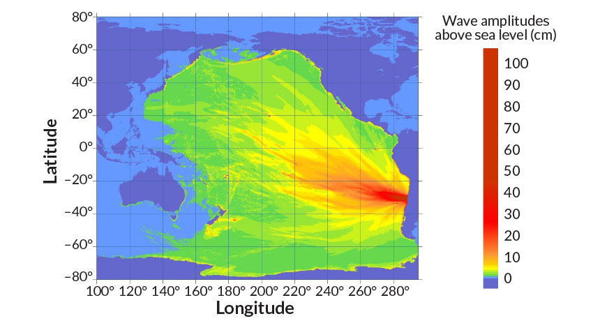
A magnitude-8.3 earthquake struck off the coast of Chile on September 16. The tsunami it triggered stretched across the Pacific Ocean. The event offered an unplanned test of a shortcut for forecasting tsunamis.
National Tsunami Warning Center/NOAA
A deadly magnitude-8.3 earthquake shook Chile on September 16. It sent a huge pulse of water racing away from its epicenter —where the quake started. The wave forced more than 1 million Chileans to flee their homes. This surging seawater also provided a surprise test for a new, faster way to predict the height of such waves.
Earthquakes that occur underwater can shift huge volumes of water. That sets off powerful waves that sometimes reach across oceans. The waves, called tsunamis (tzu-NAAM-eez), can cause massive destruction. A tsunami’s height affects how far inland waters will flood. Seismologists — scientists who study earthquakes — want to be able to quickly predict where tsunamis will reach after an earthquake happens. That way emergency managers can send help to areas that are most likely to be devastated, says Sebastián Riquelme. He’s a seismologist at the University of Chile in Santiago.
In Chile, tsunamis can reach the coast 15 minutes after an earthquake. That gives experts little time to predict how high the surging waters will rise. But Riquelme and colleagues were able to estimate the height of the Chilean tsunami just seconds after data from the recent earthquake flowed in. They did it by using mathematical predictions of how earthquakes trigger tsunamis.These researchers recently prepared a report about their new method for quickly predicting where tsunami damage will occur. It will be published in the Journal of Geophysical Research: Solid Earth. The technique can be paired with improved methods for sensing earthquakes. Doing so could make it possible to deliver accurate tsunami forecasts in half the time of current methods, they say.
“With our model, you’ll know where the damage will likely be within five minutes after the earthquake occurred,” says Riquelme.
Earthquakes frequently rock Chile. The country sits around 100 kilometers from an area beneath the Pacific Ocean that has special significance. It’s the boundary between two giant slabs that make up part of the Earth’s outer layer. The slabs are known as tectonic plates. Some plates are slowly sinking underneath others. This process is known as subduction. In the southeastern Pacific, the Nazca tectonic plate slips under South America at a rate of about 65 to 80 millimeters (about 2.5 to 3.1 inches) each year. From time to time, a section will suddenly shift and cause an earthquake. The abrupt movement displaces seawater like a stone hurled into a pond. That creates tsunami waves that can travel at speeds similar to a commercial airplane.
A tsunami’s size depends on the characteristics of the earthquake. For powerful tremors, however, local instruments called seismometers go off the charts. Seismometers detect and measure earthquake waves as they pass through the Earth. But when they are close to a powerful quake, they stop providing usable data. Seismologists must wait for the earthquake waves to travel farther away from the epicenter to get accurate readings. That costs valuable minutes.Some tsunami forecasts don’t use this detailed earthquake data. Instead, scientists come up with a list of earthquakes that could happen in the future. They then use computer models to calculate what the tsunamis from these quakes would look like. Then when an earthquake occurs, seismologists look at recordings from seismometers and search the premade list, looking for a close match. This method provides fast predictions. But they may not be very accurate.
Soon, though, networks of instruments that rely on GPS devices will be able to measure the strongest shakes and provide faster reports of earthquake activity. (GPS stations can gauge quake strength by measuring how much the ground shifts.) Once the devices are in place, seismologists could potentially calculate earthquake data in a matter of minutes. Tsunami forecasts need a speed boost to keep up.Riquelme and colleagues’ new method trades accuracy for speed. While many existing tsunami predictions rely on complex simulations, the researchers instead crafted a simple mathematical method. Using data from an earthquake that just occurred, the system estimates the amount of displaced water. That information is translated into a forecast of tsunami height — all in about 15 seconds.
The Chile quake provided the first real-time test of the method. The researchers predicted a maximum tsunami height of 5 to 6 meters (about 16.4 to 19.7 feet). Those numbers closely match early reports from the Chile quake, which created waves of 4.75 meters (15.6 feet). “We’re ready for when the GPS networks get put in place,” Riquelme says.
The method provides fast results, but its simplicity goes too far, says Eddie Bernard. He’s a retired tsunami scientist from the National Oceanic and Atmospheric Administration’s Center for Tsunami Research in Seattle, Wash. Earthquakes often trigger underwater landslides that produce even larger tsunamis than the initial tremor, he says. “You can’t just do some mathematical magic and say this is what’s happening on the seafloor.”
Power Words
(for more about Power Words, click here)
computer model A program that runs on a computer that creates a model, or simulation, of a real-world feature, phenomenon or event.
earthquake A sudden and sometimes violent shaking of the ground, sometimes causing great destruction, as a result of movements within Earth’s crust or of volcanic action.
epicenter The underground location along a fault where an earthquake starts.
GPS Abbreviation for global positioning system.
GPS device Devices that calculate their position (in terms of latitude and longitude) from any place on the ground or in the air. They do this by comparing how long it takes signals from different satellites to reach them.
magnitude (in geology) A number used to describe the relative size of an earthquake. It runs from 1 to more than 8 and is calculated by the peak ground motion as recorded by seismographs. There are several magnitude scales. One of the more commonly used ones today is known as the moment magnitude. It’s based on the size of a fault (crack in Earth’s crust), how much the fault slips (moves) during a quake, and the energy force that was required to permit that movement. For each increase in magnitude, an earthquake produces 10 times more ground motion and releases about 32 times more energy. For perspective, a magnitude 8 quake can release energy equivalent to detonating 6 million tons of TNT. (in astronomy) A measure of a star brightness.
seismometer (also known as a seismograph) An instrument that detects and measures tremors (known as seismic waves) as they pass through Earth.
seismology The science concerned with earthquakes and related phenomena. People who work in this field are known as seismologists.
subduct or subduction The process by which tectonic plates sink or slide back from Earth’s outer layer into its middle layer, called the mantle.
tectonic plates The gigantic slabs — some spanning thousands of kilometers (or miles) across — that make up Earth’s outer layer.
tsunami One or many long, high sea waves caused by an earthquake, submarine landslide or other disturbance.