Water waves can have literally seismic impacts
Seismic waves spawned by lake waves could help scientists spot risks of earthquakes
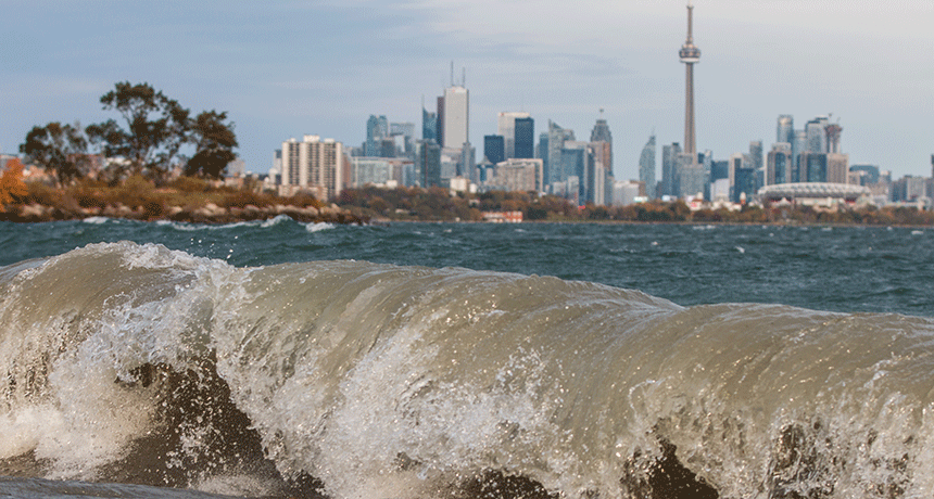
Some of the energy from waves on large lakes (such as Lake Ontario, here) gets transformed into seismic energy. Researchers are thinking about harnessing that energy in some places to map nearby earthquake fault zones.
Duentsch-Photo-Connect/iStockphoto
NEW ORLEANS, La. — The waves on large lakes carry a lot of energy. Some of that energy can penetrate the bottom and shore of the lake, creating seismic waves. These can shake the ground for kilometers (miles) around, a new study finds. Scientists now believe that recording those seismic waves could give them a load of useful data.
For instance, such data could help map underground features — such as faults —that point to possible earthquake risks. Or, scientists might use those waves to quickly tell whether lakes in remote, cloudy regions have frozen over.
Kevin Koper is a seismologist at the University of Utah in Salt Lake City. Several studies, he notes, have shown that lake waves can shake the ground nearby. But his team’s new study of six large lakes in North America and China has just turned up something interesting. Seismic waves triggered by those lake waves can shake the ground up to 30 kilometers (18.5 miles) away.
Seismic tremors are similar to the rolling waves on bodies of water. And in the new lake study, they passed by vibration-detecting instruments — seismometers (Sighs-MAH-meh-turz) — at a frequency of once every 0.5 to 2 seconds, Koper now reports.
“We didn’t expect that at all,” he says. The reason: At those particular frequencies, rock will typically absorb the waves pretty quickly. In fact, that was a big clue that the seismic waves had been generated by lake waves, he notes. He and his team couldn’t identify any other nearby sources of seismic energy at those frequencies.
Koper presented his team’s observations on December 13, here, at the fall meeting of the American Geophysical Union.
Mysteries abound
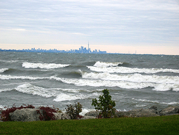
The researchers studied lakes having a range of sizes. Lake Ontario is one of North America’s five Great Lakes. It covers about 19,000 square kilometers (7,300 square miles). Canada’s Great Slave Lake covers an area more than 40 percent larger. Wyoming’s Yellowstone Lake covers only 350 square kilometers (135 square miles). The other three lakes, all in China, each cover just 210 to 300 square kilometers (80 to 120 square miles). Despite these size differences, the distances traveled by the seismic waves triggered at each lake were about the same. Why that should be is a mystery, says Koper.
His group also hasn’t figured out yet how the lake waves transfer some of their energy into Earth’s crust. The seismic waves may develop, he says, when surf pounds the shore. Or maybe large waves in open water transfer some of their energy to the lake floor. This coming summer, the researchers plan to install a seismometer on the bottom of Yellowstone Lake. “Maybe the data that instrument gathers will help answer that question,” Koper says.
In the meantime, he and his team have been hatching ideas about how to make use of a lake’s seismic waves. One notion, he says, would be to map below-ground features near large lakes. This could help researchers spot faults that might signal a region is at risk for earthquakes.
The way they’d do it would be very similar to the idea behind computerized tomography (Toh-MOG-rah-fee). It’s the process at work in the CT scanners that doctors use. These devices beam X-rays into a targeted part of the body from many angles. A computer then assembles the data they collect into a three-dimensional views of some internal tissue, such as the brain. This lets doctors look at the body part from any angle. They even can divide the 3D image into a large number of slices that look just like two-dimensional X-ray images.
But while medical X-rays are powerful, seismic waves spreading from lakes are quite faint. To amplify those signals, Koper says, his team could simply add together a lot of data gathered over months. (Photographers often use a similar technique to take pictures at night. They will leave a camera’s shutter open for an extended time. That lets the camera collect a lot of dim light to create a picture that ultimately looks sharp and well-defined.)
Seismic-wave scans also could map other things as well, suggests Rick Aster. He’s a seismologist at Colorado State University in Fort Collins. For instance, researchers might map out any large masses of molten rock beneath volcanoes.
“Every time we find a new source of seismic energy, we’ve found a way to exploit it,” he says.
Seismic waves near lakes — or their absence — might even help environmental scientists, Koper says. For instance, those waves could provide a new way to monitor the ice cover on remote lakes in polar regions. (These are places where the effects of climate warming have been most exaggerated.)
Such regions often are cloudy in the spring and fall — exactly when lakes are thawing or freezing. Satellite cameras can scan such sites, but they may not get useful images through the clouds. Detecting seismic waves of the right frequencies with lakeside instruments might provide a good gauge that a lake has not yet frozen. When the ground later quiets, notes Koper, this might signal that the lake is now capped with ice.