Did Maria set another U.S. rainfall record?
Possible rainfall record leaves forecasters baffled
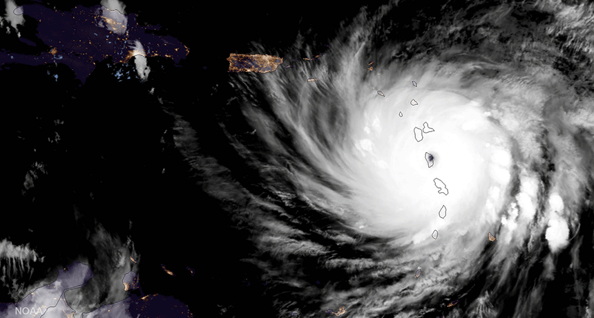
Hurricane Maria came barreling in on the Caribbean Islands last week, devastating a number of them — including Puerto Rico and the U.S. Virgin Islands. This satellite image shows the massive storm as its eye passed over the island nation of Dominica, part of the Windward Islands chain.
CIRA/ NOAA satellites/Flickr
No question, 2017’s hurricane season has been one for the record books. A rapid succession of devastating tropical cyclones have swept through the Caribbean. And each of the major hurricanes — those Category 4 and 5 — brought record conditions to at least some of the sites they ravaged. Maria, the latest, may have brought the highest one-hour deluge in U.S. history.
Just a few weeks earlier, Harvey set a different, but equally impressive, record. That massive storm hovered over parts of Texas for many days. In Jefferson County, it dropped as much as 164 centimeters (64.6 inches) of rain. The National Weather Service (NWS) office in Lake Charles, La., just released this newly finalized total. The previous record rainfall in any one U.S. site had been 52 inches. That was during a flood-producing rainstorm in Hawaii in 1950.
Then, there was Irma. It ravaged several tropical islands and large parts of western Florida. The hurricane maintained its peak Category 5 wind speeds for 37 hours, longer than any other known storm.
A week later, Maria blew in. And it laid siege to some of the same Caribbean islands just hammered by Irma. Maria reached top hurricane strength — Category 5 — as it trekked through the Virgin Islands. And it maintained this intensity until right before making landfall in Puerto Rico on Wednesday, September 20. It was there that the rains may have logged yet a new record.
Puerto Rico is a U.S. territory. Its 3.6 million inhabitants are American citizens. After having largely dodged the wrath of Harvey and Irma, Puerto Rico took a direct hit from Maria. The storm’s eyewall, where the winds are fastest, roared ashore near the island of Vieques.
Downgraded to Category 4, the hurricane still packed sustained winds of 209 kilometers (130 miles) per hour. The winds battered the landscape. But the storm’s fury unleashed more than just wind. Heavy rains came down fast and furiously. The water flooded neighborhoods. It turned streets into rivers.
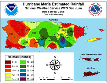
Sites across Puerto Rico saw 25 to 51 centimeters (10 to 20 inches) of rain. Some local totals topped almost a meter (3 feet). If true, this would crush the current one-hour nationwide rainfall record — and come close to breaking a world record.
Story continues below video.
Measurement challenges
It is impossible, however, to know for sure how accurate these rainfall measurements were.
Here’s why.
An automated rain gauge in the town of Caguas, Puerto Rico, reported an astonishing 31.4 centimeters (12.4 inches) of rain in just 44 minutes. Over the course of a full hour, 34.1 centimeters (13.4 inches) fell. Or did it?
There’s no doubt that huge torrents of rain came down — and fast. But when the numbers start getting up into record territory, it’s easy to “trick” a rain gauge. So finding reliable data for very short time scales is very hard.
That’s why most meteorologists resort to an “unofficial” U.S. estimate for the greatest one-hour rain total. It was set on a plantation in Kauai, Hawaii, on January 24, 1956. There, 30.5 centimeters (1 foot) of rain supposedly fell. The person taking those numbers said the gauge was overflowing, according to the weather forecasting website Weather Underground. That makes it tough to know how reliable this number is. But it certainly looks as though last week’s rain in Puerto Rico smashed the previous record.
That said, it’s unlikely that Puerto Rico’s potential record-setter will ever be confirmed. And there are three reasons for that.
The first has to do with the type of rain gauge used. Most automated NWS reporting stations are a “tipping bucket” type. This means that when enough rain falls to fill a bucket, the water’s weight causes it to tip. The water then dumps out and the machine registers a “tick.” The system counts how many ticks occurred and converts that to a rainfall total.
This seems simple enough. But when the rain comes down fast enough, the gauge has to do a lot of work. It tips back and forth and back again. It keeps repeating, and, much like a pendulum, the bucket starts to develop a rhythm. This type of rhythm, in which an object oscillates back and forth about a central point, is known as harmonic motion. There is a restoring force that tends to try to bring that object back to its central relaxed position.
This harmonic motion makes it easier for the bucket to flip — even when it’s not full. That can result in an exaggerated total.
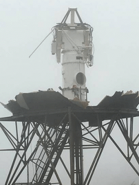
This is hardly the first time the National Weather Service has been challenged to confirm what seems to be an absurdly high rainfall total. Generally, officials will try to correlate reported totals with amounts estimated by Doppler radar. This type of radar can track both the intensity of rains and the direction the raindrops are moving. Such radar can be used to derive wind speeds inside of a cloud. In Puerto Rico, however, Maria’s winds destroyed the radar before its rainfall tally was complete.
The radar died when the winds got too high. Most NWS radar domes have been built to withstand winds up to 217 kilometers (135 miles) per hour. But Maria was stronger than that. Just before the last frame of data had been transmitted, the radar estimated incoming gusts of 241 kilometers (150 miles) per hour!
The radar’s destruction comes as no surprise. After all, it sat atop the peak of a hill several hundred meters (yards) tall. There was nothing to block the unobstructed gusts from howling in. The system’s protective dome peeled away. Pounding rains then destroyed the sensitive electronics inside. The radar had previously stood for 21 years.
The radar’s loss left the hurricane forecasters in a tricky spot during the storm. They had to get information out. With no information coming in, they were forced to turn to a backup plan. Ground-based real-time data was gone, so they consulted a brand-new weather satellite known as GOES-16. This allowed them to track from space the individual thunderstorm cells (lone thunderstorms within a larger cluster of rain) and rain bands (the spiraling arms of showers that swing around and into the eye).
Even though there was no way to know what was going on beneath the clouds, the satellite could study the cloud tops. Meteorologists called up a computer model that uses a “tracking algorithm.” It’s a type of special math formula. Certain weather models use this algorithm to make sense of what a satellite is reporting. With that computer model, meteorologists were able to estimate wind speeds, based on the observed motions of the thunderstorms’ tops.
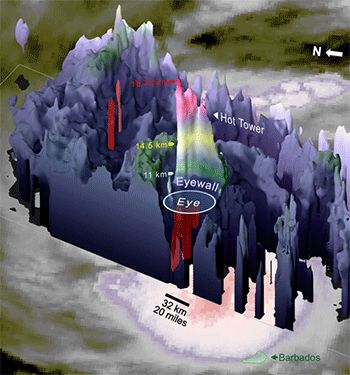
Other satellites also could play a role in verifying Maria’s possible rainfall record. NASA’s Global Precipitation Measurement satellite was parked over Maria at the time the report of a possible record came in. This satellite measures infrared radiation — a heat signature — from the cloud tops. That, together with information about the storm’s moisture content, let scientist build a 3D model of the storm. Yes, it’s another computer model. Scientists can use this model to make crude estimates about rainfall rates under storm “towers.” A tower is an exceptionally tall thunderstorm cell that can reach more than 10 kilometers (6.2 miles) high.
One so-called “hot tower” soared 16.8 kilometers (10.4 miles) into the sky. Such extreme heights point to the presence of an exceptionally powerful storm cell. And that may soon offer some clues to help solve the rainfall-record puzzle.
Wet, wet Puerto Rico
During Hurricane Maria, Puerto Rico’s mountains served as a recipe for disaster.
When water falls on such rugged terrain, it can slosh downhill and collect in valleys. There, it easily forms raging rapids. Water moving so quickly can carry away anything in its path. Vehicles, homes — even people — may be swept away.
At one point during the storm, the entire island of Puerto Rico was under a Flash Flood Warning from the National Weather Service. More than a dozen Flash Flood Warnings were issued at the same time across the island. This is the first time the whole island has been blanketed beneath warnings all at once.
Meteorologist Eric Holthaus works for the news organization Grist. He noted on Twitter that Maria’s rains swelled the Rio Grande de Loiza to a flow rate that was 200 times this river’s typical value! He shared this statistic on September 21.
What set the stage for such epic flooding? There was plentiful moisture. The oceans held huge amounts of energy, in the form of heat. Locally calm winds in the upper atmosphere over the tropics also promoted the storm’s growth. If the winds aloft are too strong, they can tear a developing hurricane apart. In the end, Maria’s rainfall over Puerto Rico appeared almost otherworldly.
One reason for this has to do with what’s known as orographics. Essentially, this refers to how the change in topography — the surface height of the land — affects weather. When air is forced uphill, the change in height makes it tougher for the air to hold water. To lighten its load, the air releases all of its excess water. This makes torrential downpours common in the mountainous tropics.
In the end, what was the most water that fell from the sky over any Puerto Rican site during the storm? Up to 99 centimeters (39 inches). That’s the best estimate. It’s also a dramatic total. It would take roughly 24,000 years for this same amount of rain to fall on Coya Sur in the Atacama Desert of Chile. One of the driest places on Earth, it averages less than a millimeter (0.04 inch) of precipitation each year. (This figure comes from a 2006 paper in the International Journal of Climatology).
Already, Category 5 hurricanes have made landfalls in the Atlantic six times in 2017. These landfalls were made by three different hurricanes (one hurricane can move over land multiple times). The year’s hurricane season doesn’t officially end until November 30. But weather models focusing on longer-range projections hint that the Atlantic will become temporarily quiet. That means hurricane activity should begin a lull lasting at least a couple of weeks.
Puerto Rico appears to be the most populous island ravaged by Maria. Its Office of Emergency Management described the island as “destroyed.” Two days after Maria had departed, Puerto Rico’s officials reported that the entire island was still without electricity. And those officials say they worry that it could take many months to fully repair the island’s crippled electricity-supply system.
But the U.S. territory is not alone. Hurricanes in 2017 stripped some Caribbean islands almost bare of vegetation. In some places, these storms damaged or destroyed nearly all the buildings. Flooding in many areas, notably on Puerto Rico, may last for weeks. And on some islands, people are running short of food, water, fuel, medical supplies and safe housing. In many places, roads remain impassable.
As tropical islands rebuild, the world can only hope that no more storms menace them for now.