Explainer: The furious eye(wall) of a hurricane or typhoon
From ‘mini-swirls’ to giant rolls of wind, the eyewall is where the real fury resides
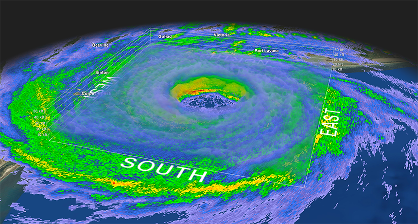
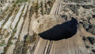
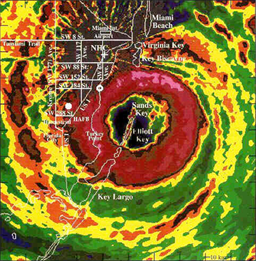
Doughnut of intense storm activity swirls about Harvey’s eyewall (green ring at center with smattering of red and yellow). This radar imagery captured hours before the hurricane’s landfall near Rockport, Texas on August 26, 2017.
National Weather Service, GR2 Analyst, M. Cappucci
People often use the phrase “eye of the storm.” It’s a term that defines part of a hurricane. It’s that small zone of calm in the midst of chaos, ferocious rains and battering destruction. The wall of winds that swirl around this quiet respite are the polar opposite of this eye. Indeed, they lash out with the cyclone’s greatest fury.
That’s saying a lot, because even the outer regions of hurricanes combine Mother Nature’s wildest weather. Their winds can blow ferociously. When their direction is right, these can sweep destructive storm surges inland across coastlines. Their clouds can dump a meter (upwards of 3 feet) of rain — or more — on inland communities. Their unstable winds can even spawn tornadoes by the dozens.
Unstable air — turbulence and rising motion — is key to building and strengthening hurricanes.
The atmosphere naturally cools the farther away you rise from the planet’s surface. That’s why ice crystals may grow outside of windows of a cloud-level airplane — even when it’s a hot summer day at ground level. When the air near the ground is extra warm, it will rise up to pierce through some of the cooler air above. This can create a localized plume of rising air known as an updraft. That’s one surefire sign that the air is unstable.
Warm sea surface temperatures and fairly unstable air are major ingredients in the recipe for a hurricane. Those conditions can serve to fuel quickly rising storm clouds.
Scientists refer to hurricanes are barotropic (Bear-oh-TROH-pik). Such storms form from vertical instabilities. That means there is no real forcing mechanism to move the air sideways. Instead, the air plumes only blossom upwards thanks to extra-chilly air aloft.
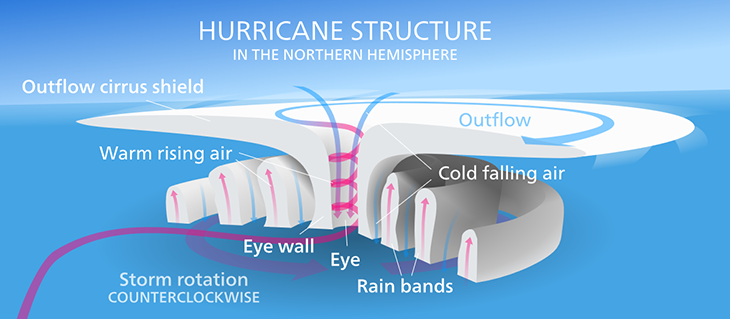
To grow, a hurricane must suck in more air. This air spirals in a counterclockwise fashion toward the center. And as it nears the middle, the air accelerates faster and faster. It speeds up just as an ice skater does when she pulls in her arms and legs.
By the time a pocket of air approaches the center, it’s now howling at destructive speeds. This air loses heat to the storm. That energy flows to the cloud-free “eye” of the storm, then exits up and out the top. Inside the eye, the winds disappear. A bit of the air curls back down towards the ground and erodes any moisture, eating away at clouds. Sometimes blue skies appear directly overhead.
Circling just outside the eye are the winds that make up the eyewall. They’re the scariest, nastiest, gnarliest part of the storm. They form an unbroken line of extremely powerful downpours. In strong hurricanes, these winds can roar to 225 kilometers (140 miles) per hour.
Twirling masses of air
Despite how strong these storms are, one thing is often missing: lightning.
With a storm so intense, one would expect its clouds to trigger plenty of lightning. Most don’t. And it all has to do with the motion of the air pockets — known as parcels — spiraling into the eyewall.
Ordinary thunderstorms develop vertically, meaning upright from the ground. It’s a bit like a bubble of air rising from the bottom of a pan of boiling water. In hurricanes, however, there is so much rotational energy that the air doesn’t climb up directly. Instead, it takes a swirly, roundabout path.
Parcels of air swirl slantwise into the storm, inward from all directions. All the while, they rise.
So while they reach the height of typical thunderstorms — 10 to 12 kilometers (6.2 to 7.5 miles) — the rising motion isn’t quite as strong, given that they’re circling like a merry-go-round. In order to spark lightning, there need to be lots of straight-up-and-down rising motion.
That’s why eyewalls only spit out sporadic bolts when a storm is intensifying — when more air is moving in the upwards direction rather than around and around. Scientists can actually gauge whether a storm is strengthening by probing how electrified its clouds are. (They do that by scanning those clouds with Doppler weather radar.)
But eyewalls don’t just produce winds with epic speed. Their winds also blow in many different directions.
Whirling fury may neighbor quiet zones
A typical hurricane eyewall tends to be about 16 kilometers (10 miles) thick. And as that eyewall moves across a site, the storm’s winds can explode within a matter of seconds.
When such strong winds hit land, they slow a bit. That’s due to friction. In the air well above us, there’s little to slow down rushing pockets of air. But near the ground, air masses can encounter all sorts of things. Trees, houses, cars and everything else serve as obstacles to the wind. Air passing over this lowest kilometer (0.6 mile) or so to the ground “feels” the effects of surface drag. That part of the atmosphere is known as the Ekman layer.
Due to the change in wind speed with height, there also can be friction between different layers of moving air. Scientists refer to this as wind shear. It’s a turning of the winds or a change in their speed with height.
Imagine you hold a pencil between your two hands. What would happen if you moved your hands in opposite directions? The pencil would rotate. The same thing happens to air masses within a storm.
We can’t necessarily see it. But people can certainly feel the results.
During Hurricane Andrew in 1992, for instance, areas of extreme damage emerged in swaths next to strips of land that escaped relatively unharmed. Each alternating “stripe” was a few hundred meters (perhaps 1,000 feet) across. They could be a kilometer or two long. Engineers coined the term roll vortex to describe what they thought was happening.
A vortex is a spinning or rotating mass of air. Much like the pencil spun in your hands, researchers hypothesized that long tube-like horizontal vortices of air could develop in the Ekman layer of a hurricane. These invisible vortices could stretch a few kilometers, and span some 300 meters (1,000 feet) across.
Later research would show much larger and more oblong roll vortices forming in less intense hurricanes. The parallel rolls would line up a few kilometers apart. That’s according to Ian Morrison and Steven Businger, researchers at the University of Hawaii at Manoa in Honolulu. Near the ground, these tubes could enhance wind speeds — a lot. And sometimes, they would hover over the same site for hours on end. That explains why some neighborhoods can see wicked winds, while a nearby community could miss the action entirely.
Why don’t these vortices move along with the storm? Well, think about a stone in a river. Downstream of that rock or obstacle, a series of miniature rolls or ripples forms. Even though the river’s current is moving swiftly, interruptions in the flow can cause vortices to form on a largely unchanging spot above it. The same process is responsible for the formation of roll vortices in hurricanes. When houses, mobile homes or any structures “interrupt” the normal flow of wind, stationary vortices may emerge.
Twirling into true twisters
But that’s not the only oddity within the eyewall. Inside those internal storms that make up the eyewall, scientists have seen evidence of tornado-like vortices causing a ruckus.
It’s long been known that tropical storms that come ashore can generate tornadoes. Swarms of them can develop in the outer rain bands once a cyclone makes landfall. It’s all thanks to that wind shear within the storm. That shear effect tends to be strongest in the forward right quadrant (one-fourth) of the storm. The vorticity — or “spin energy” — in that region can cause individual thunderstorm cells to rotate. The result? A tornado emerges within a hurricane. And like Harvey in 2017, some tropical cyclones have become prolific tornado-makers.
But eyewall twisters are different. Tornadoes shouldn’t be able to form in this part of the hurricane. Renowned tornado expert Tetsuya “Ted” Fujita was called to weigh in on the unusual damage seen in the wake of 1992’s Hurricane Andrew. And Fujita discovered something novel — mystery whirlwinds.
Fujita called them mini-swirls.
Mini-swirls may look and act like a tornado, but they form differently. Even more novel: They’re not connected to the storm clouds above.
Sometimes, small eddies may form near the ground when the wind blows around an object. Hikers may observe little vortices of dust, grass or leaves meandering across a field on a windy day. Inside the hurricane though, these swirling eddies can grow. And grow. And grow.
Because an eyewall’s winds just above the ground are so strong, they exert an upward “pull” on the air near the ground. That can stretch the tiny vortex upward a few hundred meters (yards). Suddenly it’s not so tiny.
Angular momentum is a phrase that defines the energy in a moving object that rotates. Because angular momentum (energy) is conserved, wind speeds rise dramatically as the vortex is yanked up. (Remember that figure skater that twirls ever faster as she brings her arms and legs close in to her body.) That can lead to winds of up to 129 kilometers (80 miles) per hour.
That alone may not sound so high. But imagine getting hit by one of these rotating through an eyewall where the ambient winds were already moving at 193 kilometers (120 miles) per hour. That combination could produce narrow paths of destruction a few meters wide where winds would have briefly reached 322 kilometers (200 miles) per hour!
Because of how quickly mini-swirls move, they may only impact an area for a few tenths of a second. But that’s enough to cause extreme damage. These mini-cyclones within the cyclone were one big reason why Hurricane Andrew featured damage unlike typical hurricanes.
Evidence of mini-swirls also appeared in the devastation left across the Florida peninsula in 2017 by Hurricane Irma. One was caught live on television. Mike Bettes was roadcasting from Naples, Fla., when he found himself face to face with a mini swirl. At the time, this meteorologist for The Weather Channel was standing inside the eyewall of Irma.
“You were just in the eyewall of a hurricane,” noted an anchor from the TV station’s studio. Then suddenly a whirling mass of condensing water caused Bettes to lose his footing. Whipping across the street at incredible speed, the vortex slammed just meters (yards) away from Bettes. It eventually bent a palm tree and caused more offscreen damage. Bettes escaped unscathed.