How long will Kilauea’s new eruption last?
A volcano expert tackles that and other burning questions about what’s happening in Hawaii
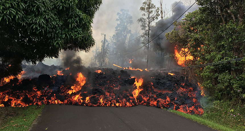
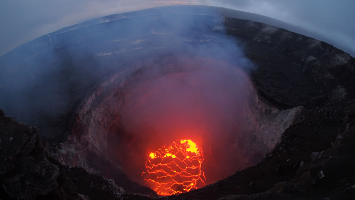
Cracks open in the ground. Lava creeps across roads, swallowing cars and homes. Fountains of molten rock shoot up to 70 meters (230 feet) high, setting treetops on fire. Last week, after a month of rumbling warning signs, Hawaii’s most active volcano began a new phase of eruptions.
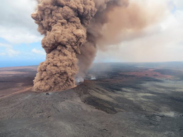
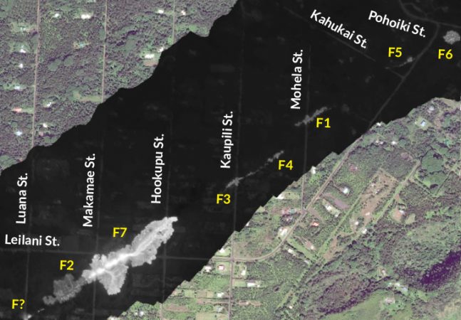
Kilauea (Kil-uh-way-uh) spewed clouds of steam and ash on May 3. Lava gushed forth through several new rifts — openings — on the volcano’s east slopes. Clouds of gas laden with toxic sulfur dioxide also burst from the rifts. This all-natural drama threatened many residents living in a community known as Leilani Estates. In all, some 1,700 were forced to flee homes directly in the path of the encroaching lava.
This is the 62nd eruption episode since 1983 along Kilauea’s eastern flank. The volcano is one of six that formed Hawaii’s Big Island over the past million years. Mauna Loa is the largest and most central peak. Kilauea, Mauna Kea, Hualalai and Kohala occupy the island’s edges. Mahukona is currently submerged. All six are shield volcanoes. That means they have broad flanks that were created by past flows of now-hardened lava.
As of May 7, activity had shifted to Kilauea’s southwest flank. That region continues to steam, although no new rifts have opened. Indeed, this eruption may be far from over, says Victoria Avery. She’s a volcanologist based in Reston, Va. She works in the U.S. Geological Survey’s Volcano Hazards Program.
Science News for Students talked with Avery about Kilauea’s fury, the quakes it has been spawning and what to expect next. Her responses were edited for brevity and clarity.
(Q&A continues below video)
Q: Is there anything unusual about this eruption?
A: Not to scientists. It’s typical of what Kilauea volcano can do.
Q: Were there any warning signs?
A: We saw shallow earthquake activity under that area for several days. That tells us that molten rock is moving underground. We also saw that the lava lake at the summit of Kilauea was lowering. There’s a vent called Pu’u ‘O’o [which has erupted nearly continuously since 1983], and the floor of that collapsed on April 30. That told us that magma is being withdrawn and moved elsewhere. That collapse, plus the new [quaking], told us something was going to happen.
Q. On May 4, two large earthquakes measuring magnitude 5.6 and magnitude 6.9 shook the Big Island in quick succession. How are they related to the eruption?
A: It’s not frequent but not unusual for Hawaii to have an earthquake like that, because a volcano is a very dynamic place. The [surface swelling] associated with the eruption probably triggered the quake[s]: The magma pushed on the volcano from inside. The whole south flank of Kilauea is an area that has a history of large earthquakes. We didn’t directly anticipate it. But we weren’t that surprised when it happened.
Q: Did the people who live there know they were in a hazardous zone?
A: The eruption is right on one of the rift zones of the volcano. Those houses are right where we know it can erupt. Right now, [emergency managers] are allowing people back in briefly to check on their homes, but not allowing them to stay.
Q: How dangerous is the gas that’s also erupting with the lava?
A: The gas is chiefly carbon dioxide and sulfur dioxide. The gas is actually what propels the [lava] to come out of the ground. Carbon dioxide in enough quantity can suffocate people. Sulfur dioxide can react with the atmosphere to create sulfuric acid. It forms vog — or volcanic fog — that can [worsen] asthma. That’s why they’re putting gas masks on people who go in to check on their homes.
Q: How are researchers monitoring this eruption?
A: We’re using the classic tools: instruments measuring seismicity and deformation, visual observations on the ground or flying over in helicopters, and thermal and deformation imagery from satellites. Using remote sensing, you can take [high-resolution images of ground elevation using a special type of radar] synthetic aperture radar (SAR) measurements at two different points in time to see the deformation. Hawaii is a supersite. So we get a lot of free SAR imagery over it, at about every two or three days. That may not be enough time for frequent eruption warnings, but it’s useful to monitor precursor activity and know what to look for. In the future, we’d like to use drones as well to monitor the eruptions.
Q: Nearby Mauna Loa is on Yellow Alert, since it’s showing signs of unrest. Is it at risk of erupting, too?
A: Mauna Loa really scares us. It is the largest volcano on the planet. It’s the big monster volcano of Hawaii. Kilauea has been erupting continuously since 1983. Mauna Loa last erupted in 1984 but can pump out much larger volumes, and much faster. It has been yellow since September 2015, when there was elevated seismicity and deformation.
Q: What’s next? Does the lull in activity at Kilauea mean the eruption is almost over?
A: It’s likely only a pause. The seismicity and deformation can wane and then build up again. The best we can do is watch precursor phenomena 24/7. [Those include] the seismic data, the height of the lava lakes and the deformation of the volcano along the rift zone. Where it swells, the magma is underneath it. Where it goes down, the magma is withdrawing.
Q: The lava lake appears to be sinking again (as of May 6). Does that suggest more eruption is imminent?
A: It generally means that the lava is traveling down the rift zone. There’s likely more to come.