angle The space (usually measured in degrees) between two intersecting lines or surfaces at or close to the point where they meet.
astronomy The area of science that deals with celestial objects, space and the physical universe. People who work in this field are called astronomers.
cartography (adj. cartographic) The science of making maps. A person who makes maps is known as a cartographer.
Charon One of five known moons orbiting the dwarf planet Pluto.
colleague Someone who works with another; a co-worker or team member.
data Facts and/or statistics collected together for analysis but not necessarily organized in a way that gives them meaning. For digital information (the type stored by computers), those data typically are numbers stored in a binary code, portrayed as strings of zeros and ones.
dwarf planet One of the solar system’s small celestial objects. Like a true planet, it orbits the sun. However, dwarf planets are too small to qualify as true planets. Prime examples of these objects: Pluto and Ceres.
elevation The height or altitude at which something exists.
ice sheet A broad blanket of ice, often kilometers deep. Ice sheets currently cover most of Antarctica. An ice sheet also blankets most of Greenland. During the last glaciation, ice sheets also covered much of North America and Europe.
journal (in science) A publication in which scientists share their research findings with experts (and sometimes even the public). Some journals publish papers from all fields of science, technology, engineering and math, while others are specific to a single subject. The best journals are peer-reviewed: They send all submitted articles to outside experts to be read and critiqued. The goal, here, is to prevent the publication of mistakes, fraud or sloppy work.
moon The natural satellite of any planet.
mosaic Something made from an assembly of different types of objects. (in biology) An organism made of cells from two genetically different types or exhibiting behaviors of different types (or sexes).
NASA Short for the National Aeronautics and Space Administration. Created in 1958, this U.S. agency has become a leader in space research and in stimulating public interest in space exploration. It was through NASA that the United States sent people into orbit and ultimately to the moon. It also has sent research craft to study planets and other celestial objects in our solar system.
online (n.) On the internet. (adj.) A term for what can be found or accessed on the internet.
physical (adj.) A term for things that exist in the real world, as opposed to in memories or the imagination. It can also refer to properties of materials that are due to their size and non-chemical interactions (such as when one block slams with force into another).
planet A celestial object that orbits a star, is big enough for gravity to have squashed it into a roundish ball and has cleared other objects out of the way in its orbital neighborhood. To accomplish the third feat, the object must be big enough to have pulled neighboring objects into the planet itself or to have slung them around the planet and off into outer space. Astronomers of the International Astronomical Union (IAU) created this three-part scientific definition of a planet in August 2006 to determine Pluto’s status. Based on that definition, IAU ruled that Pluto did not qualify. The solar system now includes eight planets: Mercury, Venus, Earth, Mars, Jupiter, Saturn, Uranus and Neptune.
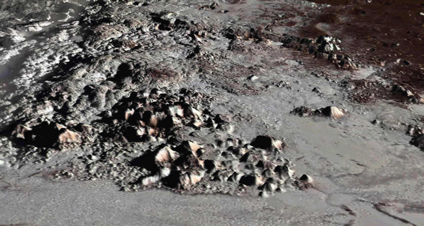
Pluto A dwarf planet that is located in the Kuiper Belt, just beyond Neptune. Pluto is the tenth largest object orbiting the sun.
terrain The land in a particular area and whatever covers it. The term might refer to anything from a smooth, flat and dry landscape to a mountainous region covered with boulders, bogs and forest cover.
trough A channel, gully or depression in the land that can collect liquids. Or a container with a U-shaped bottom from which animals may feed or drink. (in physics) the bottom or low point in a wave.